Geographic Information Systems
Elevate Your Skills
The graduate certificate in Geographic Information Systems (GIS) at ETSU teaches students to use state-of-the-art geospatial technology to answer questions, solve problems, and manage resources and assets.
Classes can be taken online, in person, or a combination of both. Introductory level courses offer foundational knowledge and advanced courses teach the skills needed to get to the next level.
GIS is routinely applied in mapping, remote sensing, urban planning, emergency management, hazard mitigation, surveying, public health, agriculture, geology, archaeology, and so much more!
Gain Professional Competencies
Study the fundamental concepts of Geographic Information Science and Technology and learn basic and advanced functions of geospatial software and hardware.
- Learn fundamental remote sensing and spatial analysis techniques, including the creation and acquisition of original spatial data. Data may come from a variety of sources including regional, national, and international databases. These may include live data feeds, virtual feature services, ground-penetrating radar, small Unmanned Aerial Vehicle platforms, and other sensors.
- Automate spatial analysis processes through model building and basic code development.
- Apply advanced analysis techniques using multiple proprietary and open-source GIS platforms.
- Manage a comprehensive geospatial project.
- Learn multidisciplinary modeling techniques and design webmapping, mobile applications, or servers.
Program information including curriculum and graduation requirements can be found in the ETSU Graduate Catalog.
Customize Your Learning
Required courses:
- GEOS 5010 - Geospatial Analysis*
- GEOS 5317 - Advanced Geographic Information Systems*
Courses with an asterisk* are offered online (could be synchronous or asynchronous).
Choose two courses from advisor-approved electives:
- GEOS 5017 - Advanced Cartography: Web and Mobile Mapping*
- GEOS 5300 - Topics in Geospatial Analysis*
- GEOS 5320 - Geographic Information Systems Projects
- GEOS 5350 - Statistics for Geosciences
- GEOS 5900 - Independent Study*
- Other courses may include GEOS 5237 - Advanced Remote Sensing and GEOS 5807 - Unmanned Aerial Systems (UAS) Mapping and Modeling
An Adaptive and Flexible Certificate Program
With a focus on technical proficiency, the GIS certificate allows students to seek a job in the rapidly growing GIS field or increase opportunities within their current career path. This certificate is especially useful for those wanting to add skills to either their existing degrees or professionals already in the workforce.
Steps to Apply
-
Step 1 - Create your ETSU Application Account
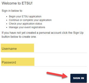
Step 1 Create your ETSU Application Account by choosing the "Sign Up" option

-
Step 2 - Sign into the ETSU Application Portal
Step 2 Sign in to the ETSU Application Portal and select "Start a New Application"

-
Step 3 - Complete the Remaining Fields
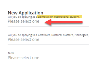
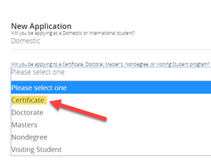
Step 3 Choose "Graduate," select your student type (domestic or international), select "Certificate," term, then choose Geographic Information Systems and complete the remainder of the form.


Cost
Credits to complete this program: 12 credit hours
Please note that enrollment in an on-ground course affects out-of-state student eRate
eligibility.
| TN Residents | *eRate | Out of State |
|---|---|---|
| $672 per credit hour | $835.50 per credit hour | $1,513 per credit hour |
| - The *eRate applies to students living out of state and taking all web-based courses. - Additional fees may be required. - Visit the Paying for College page to read more about costs and financial aid options. - The costs associated with attending ETSU can include both direct and indirect costs. Please review ETSU's Cost of Attendance for more details. |
||
Frequently Asked Questions
-
What accreditations apply to this certificate program?
East Tennessee State University is accredited by the Southern Association of Colleges and Schools Commission on Colleges (SACSCOC) to award baccalaureate, master’s, education specialist, and doctoral degrees. East Tennessee State University also may offer credentials such as certificates and diplomas at approved degree levels. Questions about the accreditation of East Tennessee State University may be directed in writing to the Southern Association of Colleges and Schools Commission on Colleges at 1866 Southern Lane, Decatur, GA 30033-4097, by calling (404) 679-4500, or by using information available on SACSCOC's website (www.sacscoc.org).
-
Does this certificate lead to certification or licensure in this field?
This program prepares students to become certified as an Emerging GIS Professional (GISP-E). Our classes and the certificate can also be counted toward the educational achievement component of the GIS Professional (GISP) certification.
-
What are the job prospects with this certificate?
Graduates are well-positioned to enter the workforce or advance their careers. GIS is interdisciplinary and applied in various professions, such as utilities management, energy development, conservation planning, public health, and natural resources management.
-
Is a master’s degree required for admission?
A master's degree is not required for this program, and a student's undergraduate degree does not have to be related to this field.
-
What are the prerequisites?
There are no prerequisites, although students with no background or prior coursework in GIS are advised to take classes in a certain order (students will work with the certificate coordinator when enrolling in classes).
-
Does this certificate require the GRE or GMAT?
Neither the GRE nor the GMAT are required.
-
Are the courses for this certificate asynchronous or synchronous?
Classes for this certificate are both synchronous and asynchronous.
-
What are the traditional meeting times for the synchronous courses, and how often are they held?
Synchronous classes are normally during the day (usually just before noon) for 1.5 hours twice per week. For GIS classes, much of this time is dedicated to lab and Q&A time, while a smaller portion is allotted for formal lecture/discussion/etc. Depending on the student's situation, faculty can be flexible with class time concerns.
-
Are there any on-campus requirements?
No. Students who prefer an on-campus experience have the opportunity to take in-person courses (those listed as elective options), which could provide additional skills that may be difficult to obtain through the online-only course options (e.g., UAV/drone flight experience, field techniques/remote sensing experience, etc.).
-
Does this certificate require field work or an internship?
No. However, internships are helpful. The Department of Geosciences consistently communicates internship opportunities and maintains critical relationships with regional employers, stakeholders, and alumni. These opportunities can often lead to job opportunities for students.
-
Is this certificate designed to meet the needs of adults who work full-time and/or have family obligations?
Yes, the online-only option is highly flexible! The online structure of the program is ideal for those with professional and/or familial obligations.
-
What is the time to completion?
Full-time: 2 semesters.
Part-time: 4 semesters.
-
When can I start?
Students may start in the fall or spring semesters.
-
Does the department offer scholarships?
No, the GIS certificate program does not have any program-specific scholarship opportunities. Students are also encouraged to visit the Paying for Graduate School website for information regarding ETSU graduate scholarships and other financial resources.
The department offers scholarships, awards, and assistantships to those pursuing the master's degree. Certificate students can articulate into that program if desired (allowing all hours from the GIS-C to count towards the master's degree).
 Stout Drive Road Closure